
SALT LAKE CITY — Utah’s drought situation has worsened in recent weeks as its record-low snowpack melts off, even prompting Gov. Spencer Cox to issue a drought declaration. As he spoke about the dry …
SALT LAKE CITY — Utah’s drought situation has worsened in recent weeks as its record-low snowpack melts off, even prompting Gov. Spencer Cox to issue a drought declaration.
As he spoke about the dry conditions, federal forecasters unveiled new long-range weather models that signal some hope on the horizon.
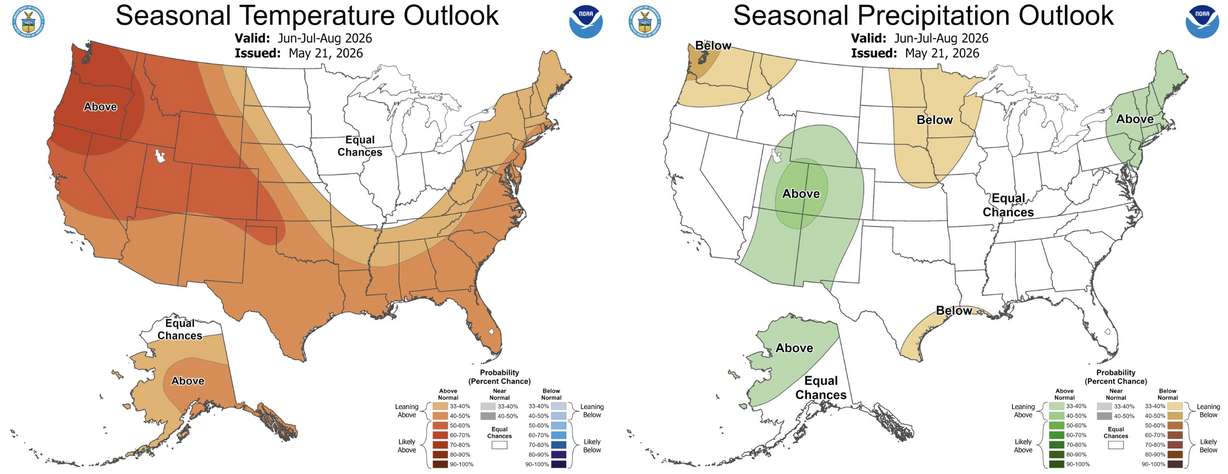
Most of Utah and the Four Corners states are listed as having stronger odds for above-normal precipitation this meteorological summer, which runs from June 1 through Aug. 31, according to an updated three-month outlook from the National Weather Service’s Climate Prediction Center released on Thursday.
Experts say that it won’t solve all the problems caused by the poor snowpack, but it could help ease some of the challenges the state is facing this summer, should the forecast come to fruition.
“It’s kind of what we’ve been hoping for,” said KSL meteorologist Matt Johnson. But he and others warn that a projected El Niño oceanic pattern this summer may affect how everything plays out.
What’s expected this summer?
The center’s report lists most of Utah as having between a 33% and 50% shot of above-average precipitation throughout the meteorological summer months of June, July and August. Utah’s western edge is listed as having “equal chances,” meaning there’s no clear signal for a wetter, drier or near-normal season, while the strongest odds are in eastern Utah.
The state also has a 40% to 50% probability of above-normal temperatures, potentially adding to a trend for this summer and the year as a whole.
However, there are many caveats to consider, starting in the Pacific Ocean.
Forecasters say there’s now an 82% probability that an El Niño pattern will develop by the end of July. This happens when Pacific Ocean trade winds that push surface waters toward Asia weaken, allowing for warmer water to remain closer to the American coast.
While its weather impacts are more pronounced in the winter, a summer El Niño can affect the Western monsoon, said Basil Newmerzhysky, fire meteorologist for the Great Basin Coordination Center.
Western monsoons occur when moisture from the oceans is drawn over the region, producing showers and thunderstorms. These typically develop in Arizona and New Mexico by mid-June, before reaching Utah by mid-July. They can linger into August and September, too, but the oceanic pattern can alter timelines.
“It’s really tricky right now. If the El Niño strengthens a little bit more, that monsoon can be delayed by several weeks,” Newmerzhysky said, noting that it typically still arrives in these scenarios, but potentially in August.
El Niño’s potential impacts could also create periods of stronger moisture at one point of the summer and not evenly across the season, meaning potentially dry conditions at the start. Great Basin Coordination Center officials previously said it could “make or break” Utah’s fire season.
An El Niño setup can also push the monsoon eastward, which is likely why models hint toward eastern Utah having stronger precipitation odds. It’s going to depend on the predominant high-pressure and low-pressure systems set up over the summer, Johnson said.
All of this is probabilistic and doesn’t project how much more above-normal any precipitation could be, though, which are other caveats.
There’s usually a correlation between a bad winter snowpack and a good ensuing summer monsoon, Johnson explained. But Utah experienced its eighth-hottest and 15th-driest summer since at least 1895 last year, despite a somewhat favorable forecast for Utah after a poor snowpack across central and southern parts of the state.
Monsoonal moisture is also notoriously difficult to forecast. Gulf moisture mixes with heat that creates isolated afternoon showers, which can create massive downpours in some areas while skipping neighboring areas in some cases.
“The likelihood that we see above-normal precipitation over this three-month period is enhanced. The signal is definitely there for it to happen,” Johnson said, adding there’s no guarantee that it will happen for everyone in the state.
Why it matters
A productive monsoon wouldn’t fix all of the state’s water woes. The state’s reservoir system, which relies more on snowpack runoff, is 70% full, slightly below the median average for May. It’s the first time it’s been below the median in years, following the record-high snowpack in 2023.
When combined with current drought conditions, monsoons can also cause damaging floods.
Yet, if the right conditions align, monsoons can improve soil moisture and groundwater supplies while reducing fire risk and evaporative losses from lakes and reservoirs.
That would be the ideal situation for Utah, given its drought.
“It’s going to be interesting to see how this all pans out,” Johnson said.
The Key Takeaways for this article were generated with the assistance of large language models and reviewed by our editorial team. The article, itself, is solely human-written.
Source: Utah News